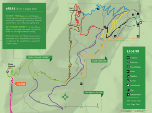
Herron Park/Chase Forest Trails Map – The latest map (September 2018) is ready! Highline Design has created an updated (includes the Spirit Bear Connector and the Foy’s to Blacktail Trail), pocket-sized map that covers all the ground. These maps are available at the main parking lot kiosk as well as Rocky Mountain Outfitter, Wheatons, and the Chamber of Commerce, all in downtown Kalispell. They are also available at Sportsman & Ski Haus in Kalispell, Glacier Cyclery in Whitefish, and Tamarack Brewing in Lakeside. If you’re in a hurry, you can download a map in PDF, but we encourage you to get a hardcopy as they’re sturdy, easy to fold, and easier to read than the PDF.
Always yield to horses and STOP to Say Hi when approaching.
Using the Trails – For decades, the trails in and around Herron Park were user-created, unplanned and unsustainable. Beginning in 2009, FTBT (with crews from Montana Conservation Corps and volunteers) began building and maintaining professionally designed trails in Herron Park and the John Chase Forest. These trails are shared by hikers/runners, equestrians and cyclists, so safety is important. The Boundary Trail (completed in 2017) is one of two latest additions to approximately 17 miles of stacked loop trails.
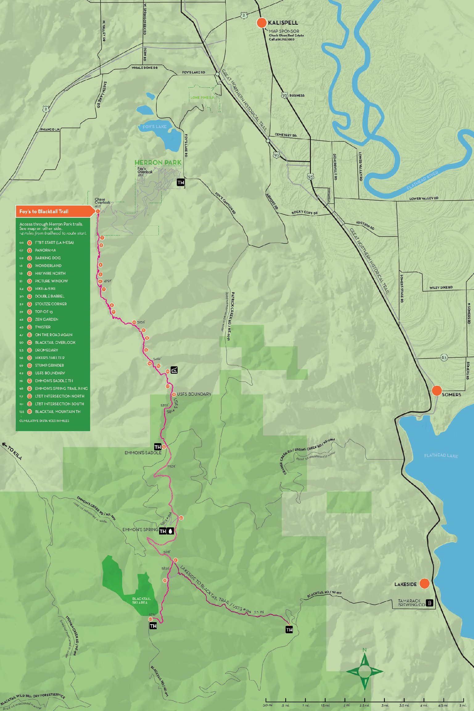
The Foy’s to Blacktail Trail
Most of the land extending south from Herron Park to Blacktail Mountain is owned either by Southern Pines Plantation, Stoltze Lumber Company, or the U.S. Forest Service (see map below).
FTBT worked diligently with private landowners between Herron Park and Emmons Saddle to obtain a permanent trail easement through their property. The easement was secured in spring 2017, allowing non-motorized public recreation within the Foy’s to Blacktail Trail (FTB Trail) built on their property. The trail was completed in August 2017.
Signage and maps were completed in the summer of 2018. In general, from the Herron Park trailhead to the top of Blacktail Mountain is around 18 miles. The official route of the FTB Trail is 18.8 miles: begin at Herron Park, proceed along the Notch, Boundary, and Chase trails to the beginning of the FTB Trail at La Mesa. From here, it is 13.5 miles to the summit of Blacktail Mountain.
Trailheads
There are 5 trailheads in the FTBT trail system: Herron Park, Emmons Saddle, Emmons Spring, Lakeside to Blacktail, and Blacktail Mountain. As of summer 2020 only Herron Park and Lakeside to Blacktail trailheads are developed. See below for general descriptions.
Herron Park TH
Located along Foy’s Canyon Road, go 6 miles west of Kalispell on Foy’s Lake Road. Pass Foy’s Lake and Herron Park will be on your right. Look for the Foy’s Community Center, asphalt parking lot, and flat-roofed kiosk to guide you in. There is parking at the main lot and down the road at the stables area. There are pit toilets available at both the main parking and stables areas. The Foy’s Community Center is only available by reservation through Flathead County Parks & Recreation.
Lakeside to Blacktail TH
Located on the Blacktail Road, go 5 miles west of Lakeside and find the trailhead sign on your right. Go up the dirt road for 1 mile and follow signs to the parking area. There is a pit toilet here and limited parking in the main area. This trail is called Lakeside to Blacktail. The intersection with the FTB Trail is 3.5 miles from the TH and the summit of Blacktail Mountain is 5.6 miles.
Emmons Saddle TH
From Herron Park, go 2 miles south on Foy’s Canyon Road to Patrick Creek Rd. Turn right and proceed 9.3 miles up Patrick Creek Road (splits to the left after two miles to steep incline) to where the Foy’s to Blacktail Trail crosses the road. There is an improved trailhead with a parking lot, pit toilet, and informational kiosk. From the Emmons Saddle TH, Herron park is 11 miles to the north and Blacktail Mountain is 4.6 miles to the south. Signage in this area was reinstalled in June 2022 but continues to have issues with vandalism.
Emmons Spring TH
Continue down Patrick Creek Road (often referred to as Emmons Creek Road or West Patrick Creek Road) for 2 miles. There is a small pull out and primitive spring box on the left (south) side of the road. The Emmons Spring Trail is a short scramble up the hillside where it connects to the Foy’s to Blacktail Trail after .75 miles.
Blacktail Mountain
Drive all the way up Blacktail Road (14 miles) and turn right immediately before the sign for the ski resort. There is no car access to the trailhead from the ski resort lodge. Rather, turn right at the Blacktail Ski Area sign and drive up past the radar ball and look for a basic trailhead sign on your left.
The Foy’s to Blacktail Trail map can also be downloaded.

